
Geological Ages Written in Stone: Reading Rock Formations in Wild Landscapes
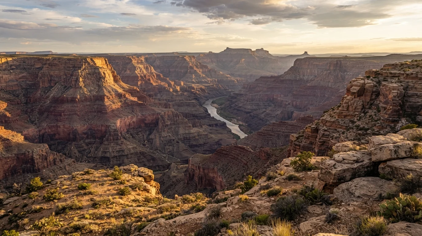
Photo credit: ExploreRoute.net | Travel Made Simple
In this article
The cliffs, canyons, and outcrops of remote wilderness are living records of Earth's history. Learn to interpret what you're actually looking at.
Key Takeaways
- Rock layers, called strata, are geological records of ancient environments including seas, deserts, and swamps.
- Color, texture, and fossil content in stone each reveal different conditions from Earth's deep past.
- Tilted or folded strata indicate tectonic forces that have deformed the landscape since the rocks originally formed.
- Remote wilderness sites often expose longer, less-disturbed geological sequences than accessible tourist areas.
- No specialized equipment is needed to begin observing and interpreting basic rock formations in the field.
The Stone Archive Beneath Your Feet
Most travelers stand at a canyon rim and see scenery. The geologically curious see something closer to a library — one written over hundreds of millions of years and opened for inspection by the simple fact of erosion. Every horizontal band of color striping a cliff face represents a distinct chapter: a shallow inland sea that covered this land 300 million years ago, a field of wind-driven dunes that hardened into Navajo Sandstone, a volcanic winter that left a thin dark seam across an entire continent.
The great appeal for off-the-beaten-path travelers is that the most legible rock sequences are frequently found far from crowded trailheads. Remote wilderness areas — forgotten plateaus, canyon systems without paved access — tend to preserve longer, less-disturbed stratigraphic columns precisely because human infrastructure has left them alone. The reward for reaching them is not just solitude but geological depth that more accessible sites rarely match.
4.5 billion
Years of Earth's geological history recorded in rock
Earth's oldest known rock formations date to approximately 4 billion years ago; the geological timescale spans the planet's entire 4.5-billion-year history.
~270,000 ft
Thickness of sedimentary rock sequence in the Grand Canyon region
The Colorado Plateau preserves one of the most complete sedimentary sequences in the world, with some estimates placing the full column of rock layers at extraordinary cumulative depths.
1 inch
Approximate sediment accumulation per 1,000 years in calm marine environments
Sedimentary geologists use deposition rates to calculate how long a given layer took to form; rates vary widely depending on environment and conditions.
Decoding What You See: Color, Texture, and Structure
Three observable qualities unlock most of what a rock face is trying to tell you. Color signals ancient chemistry. The blazing reds and oranges of formations like the Entrada Sandstone in Utah reflect iron-rich sediments oxidized in warm, arid conditions — ancient desert environments made permanent. Pale grays and greens hint at oxygen-poor, waterlogged settings such as swamps or deep-sea floors. A sudden black seam may mark a mass extinction event or an episode of intense organic accumulation.
Texture and grain size speak to energy. Coarse, gritty sandstone suggests high-energy environments — powerful rivers or wind. Smooth, fine-grained mudstone or shale points to calm, slow-moving water where only the finest particles could settle. Limestone's crystalline or fossiliferous character almost always means a marine origin, its calcium carbonate derived from the skeletal material of ancient sea creatures.
Structure — whether layers are horizontal, tilted, or wildly folded — records what happened to the rock after it formed. Horizontal strata are the baseline, the original resting position. Tilted or folded layers tell of tectonic upheaval: mountain-building events that crumpled the crust like a slow-motion collision. If you're driving through the Appalachians and notice ridgelines of dramatically upended stone, you're seeing the eroded roots of what were once Himalayan-scale mountains. Reading these structural clues from the driver's seat transforms an ordinary scenic highway into a moving geological lecture.
Start with Color Before Anything Else
When approaching an unfamiliar rock face or canyon wall, train your eye on color bands first — they're the easiest feature to distinguish from a distance and often the most informative. Note where colors change abruptly versus gradually, and whether the same color appears in multiple layers separated by different-colored rock. This simple exercise builds pattern recognition quickly and gives you genuine interpretive purchase before consulting any reference material.
Deep Time and the Art of Paying Attention
The harder adjustment for most visitors isn't technical — it's temporal. Human intuition is calibrated for decades, perhaps centuries. Geology operates in increments of millions of years. A single exposed cliff face at a remote Utah canyon may span more time than the entire existence of complex animal life on other planets, if we knew of any. Holding that scale in mind changes how a place feels.
Fossils, when present, anchor that abstraction to something recognizable. A trilobite imprinted in limestone is a direct physical record of an organism that lived before dinosaurs, before flowering plants, before birds. You don't need to identify species — the presence of marine fossils in a landlocked desert canyon alone is enough to communicate something extraordinary: this land was once a seafloor.
For travelers who already seek out the stories embedded in ancient ruins, rock formations offer the same pleasure of independent interpretation, scaled to geological rather than human time. Both require slowing down, looking carefully, and resisting the urge to move on before the place has had a chance to speak. The geographic clues that point toward hidden natural wonders — subtle shifts in topography, unusual soil colors, exposed ridgelines — are often the same features that signal rich geological storytelling beneath the surface.
It's also worth noting that some of these landscapes are changing. Natural forces and climate shifts are quietly altering extraordinary landscapes, accelerating erosion in some regions and submerging coastal geological exposures in others. The stone archive is durable, but access to it is not always guaranteed.
Safety and Access Considerations
Many of the most geologically rich exposures are found in remote terrain with limited infrastructure — no cell service, unmarked trails, and significant exposure to weather. Always inform someone of your planned route, carry adequate water and navigation tools, and check conditions with the relevant land management agency before visiting. Rock faces and canyon edges can be unstable; observe formations from safe distances and never collect rocks, minerals, or fossils from federal or protected lands without a permit.
Frequently Asked Questions

Author
Hidden Destinations Editorial Team
Hidden Destinations Editorial Team is the collective byline for our editorial team and contributor network. Articles published under this byline or an editorial pen name are researched, written, and reviewed according to our editorial standards for clarity, consistency, and independence before publication.
View all articles →