
Pacific Coast Highway vs. Route 66: Which Classic Drive Suits You?
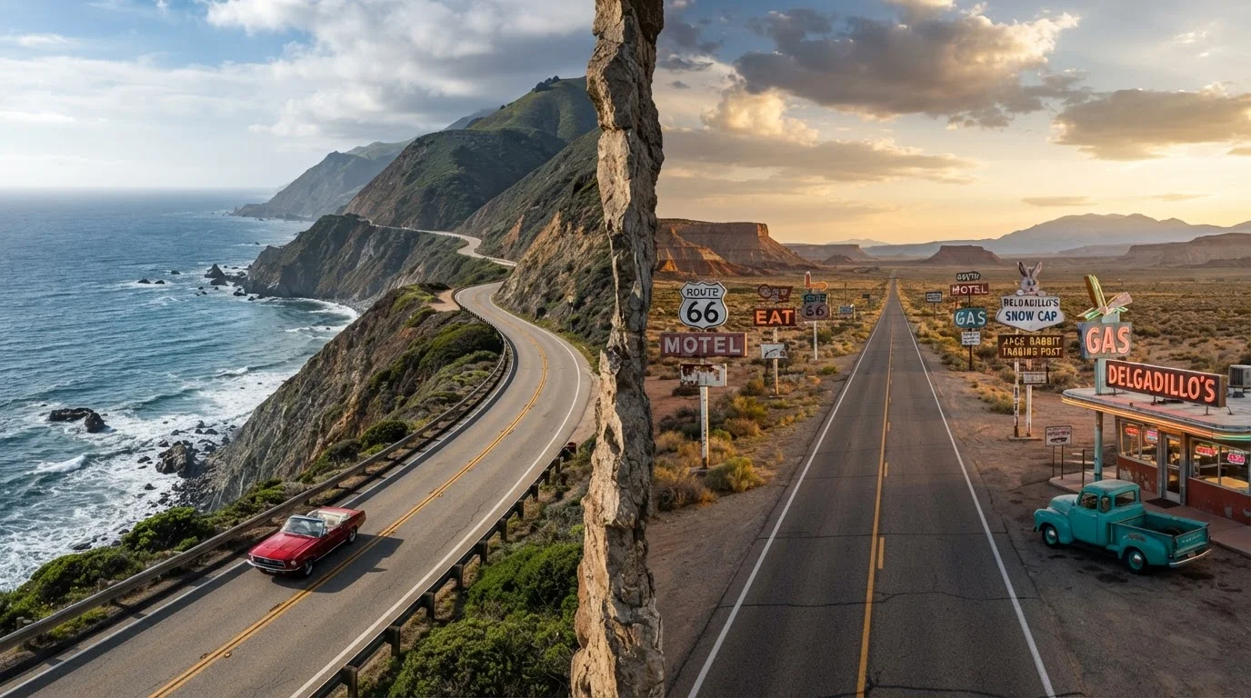
Photo credit: ExploreRoute.net | Travel Made Simple
In this article
Ocean cliffs and redwoods or desert diners and neon signs — two legendary American drives, two very different experiences.
Key Takeaways
- Pacific Coast Highway hugs California's shoreline for roughly 650 miles of ocean views, redwoods, and coastal towns.
- Route 66 stretches about 2,400 miles from Chicago to Santa Monica through deserts, small towns, and Americana history.
- PCH suits travelers who want concentrated scenic beauty; Route 66 rewards those chasing cultural depth and variety.
- Both routes have gaps, closures, and seasonal considerations worth researching before you depart.
- Your ideal drive depends on pace preference, regional interests, and how much total mileage you want to cover.
The Big Picture: What These Roads Actually Are
Pacific Coast Highway — most commonly associated with California State Route 1 — traces the state's coastline from Leggett in the north to Dana Point in the south, with Big Sur and the Monterey Peninsula as its dramatic centerpiece. It's a visually concentrated drive where the ocean is rarely out of sight.
Route 66, officially decommissioned in 1985 but still very much alive as a heritage route, runs from Chicago's Lake Shore Drive to Santa Monica Pier — crossing Illinois, Missouri, Kansas, Oklahoma, Texas, New Mexico, Arizona, and California. It's a geographic and cultural cross-section of the American heartland. For a deeper look at its storied past, see the full history of Route 66.
The core difference: PCH is a single, cohesive coastal corridor. Route 66 is a patchwork of eras, landscapes, and communities stitched together by asphalt and ambition.
Landscapes and Scenery
PCH's scenery is relentless in the best possible way. The route passes through the misty redwood forests near Leggett, the wind-sculpted cliffs of Big Sur, the cypress groves of Monterey, and the warm beaches of Malibu. The visual drama is coastal and largely uninterrupted.
Route 66 is more heterogeneous. It opens in Chicago's urban sprawl, softens through Missouri's rolling Ozarks, flattens across the Oklahoma and Texas panhandles, then explodes into the red rock country of New Mexico and Arizona before descending into the Mojave Desert. The Painted Desert and Petrified Forest in Arizona alone could anchor a separate trip.
| Pacific Coast Highway | Route 66 | |
|---|---|---|
| Total Distance | ~650 miles (full CA route) | ~2,400 miles (Chicago to Santa Monica) |
| Primary Landscape | Coastal cliffs, ocean, redwoods | Deserts, plains, Ozarks, small towns |
| Recommended Duration | 3–7 days | 14–21 days |
| Cultural Character | Natural scenery, coastal communities | Americana history, roadside kitsch, diverse states |
| Road Conditions | Winding 2-lane, landslide risk in Big Sur | Patchy; some segments unpaved or decommissioned |
| Best Season | Late spring, early fall (avoid fog/slides) | Spring and fall (avoid desert summer heat) |
Travelers who want PCH's lesser-celebrated stretches — quieter coves and forgotten fishing towns most drivers bypass — will find useful guidance in our look at PCH's most overlooked stretches.
Iconic Stops Along Each Route
PCH highlights include Hearst Castle perched above San Simeon, the elephant seal colony at Piedras Blancas, the tide pools of Morro Bay, and the Danish-influenced village of Solvang. In the north, Point Reyes National Seashore offers some of the most dramatic coastal hiking on the continent.
Route 66 highlights span a far wider range: the Cadillac Ranch outside Amarillo, the Blue Whale of Catoosa in Oklahoma, Wigwam Motel in Holbrook, Arizona, and the neon-lit stretch of old downtown Albuquerque along Central Avenue. The Santa Monica Pier provides a satisfying symbolic finish line at the Pacific.
Plan Around the Shoulder Seasons
Both PCH and Route 66 hit their stride in spring (April–May) and fall (September–October). Summer brings crowds to PCH's coastal towns and punishing heat to Route 66's desert stretches. Shoulder-season travel generally means clearer roads, cooler temperatures, and a more relaxed pace at the stops that matter most.
Both routes have sections that require detours or are no longer fully contiguous. Before driving Route 66, it's worth reviewing common Route 66 myths to set realistic expectations about which segments remain driveable.
Logistics: Time, Distance, and Practicality
A focused PCH drive from San Francisco to Los Angeles — the core stretch most travelers choose — covers roughly 400 miles and can be done in three to five days comfortably. Extending north through the Lost Coast and Humboldt redwoods adds depth but also significant mileage on winding two-lane roads.
Route 66's full 2,400-mile run realistically needs two to three weeks if you intend to explore the towns and roadside attractions that give the route its soul. Rushing it misses the point entirely. Accommodations are generally plentiful on both routes, though Big Sur's options are more limited and popular spots book up quickly in summer.
~2,400 mi
Full length of historic Route 66
Route 66 spanned eight states from Chicago to Santa Monica before its official decommissioning in 1985.
~650 mi
California State Route 1 total length
California's Route 1 runs the length of the state's coastline, with the Big Sur section considered the most scenic.
Seasonal timing matters on both routes. PCH through Big Sur is vulnerable to landslides and road closures — always check Caltrans road conditions before traveling. Route 66's desert sections in Arizona and New Mexico can be brutally hot in July and August; spring and fall are widely considered the most comfortable seasons. Always verify current road conditions through official state transportation agencies before you depart.
Which Road Fits Your Traveling Style?
If you're drawn to the rhythmic quality of a single landscape evolving gradually — ocean light shifting from morning fog to afternoon gold — PCH is the move. It's also a more practical choice for travelers joining from outside the US who want a geographically compact, highly photographable experience. Those hungry to explore beyond the main corridor can branch out; our guide to coastal backroads beyond PCH maps out equally striking alternatives along the Pacific and beyond.
Route 66 suits the traveler who finds meaning in texture: the crumbling motor courts, the hand-painted signs, the small-town diners where the coffee is bad and the stories are great. It's a route that rewards curiosity and patience over efficiency. For another legendary road that tests both qualities, the Loneliest Road in America across Nevada offers a compelling contrast in solitude and scale.
Ultimately, both routes are genuinely worth doing — and for the committed road tripper, doing both (on separate trips or as part of a larger loop) is the most satisfying answer of all.

Author
Road Trip Culture Editorial Team
Road Trip Culture Editorial Team is the collective byline for our editorial team and contributor network. Articles published under this byline or an editorial pen name are researched, written, and reviewed according to our editorial standards for clarity, consistency, and independence before publication.
View all articles →